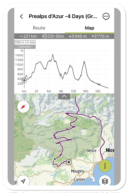
August 2023: (220km, +3,450m elevation gain)
Well, lounging by the seaside is not our thing anymore, especially in the tourist-packed region of the Côte d’Azur. But just inland there are vast mountainous areas, with very little population, infrequent villages, and amazing scenery. And so we evaded for a little bike tour in the Regional Park of the Prealps d’Azur.
I planned the first 3 stages in a very relaxed format for an ebike trip, wanting to arrive early at each lodging to enjoy the villages and their surroundings. But finding lodging in this area is almost impossible, and that is also what forces the length of the bike segments.
*****************************************
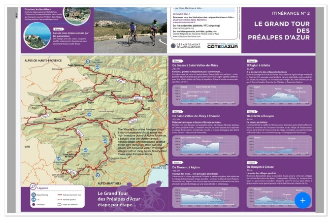
DAY-1 (Grasse to Saint Césaire to Saint-Vallier-de-Thiey): 29km, +760m.

The first day was purposely short, starting in the late afternoon to avoid trains crowded with beachgoers. The TER train are really packed along the coast during the “swimming” times, so be careful to choose the right time to load bicycles .
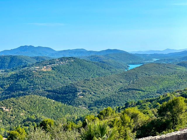
The landscape of this first day is green with gentle hills but still trafficked and more populated compared to the upcoming days. There’s maybe a kilometer of bike lane, but that is it for the rest of our trip, always on road shared by cars, although quieter for days 2 & 3.
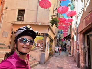
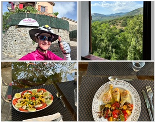
The bike departure point of the trip is Grasse, easily reached by TER train, with free bike transport. The old Grasse, at 350m, is perched above the newly developed town, indeed quite a hike from the train station. The main tourist attraction of Grasse is its Parfumerie Fragonard. However, the old town, the many little tourist shops and the beautiful panoramic views are also worth a look.


Left Grasse, the road brought us through a few villages on the green hills of Provence.

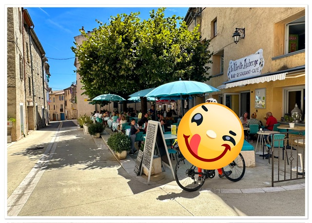
If looking for some additional activity, in Saint-Cézaire one can visit the Caves/Grotto, with a 200m course through stalagmites, stalactites, and sculpted cave walls (https://www.grotte-saintcezaire.com/en/ ). We passed this activity and continued onto our night destination, the village of Saint-Vallier-de-Thiey, the last place where we would find multiple Lodging and Food sites.
**************************************
DAY-2 (Saint-Vallier-de-Thiey to Thorenc): 45km, +880m
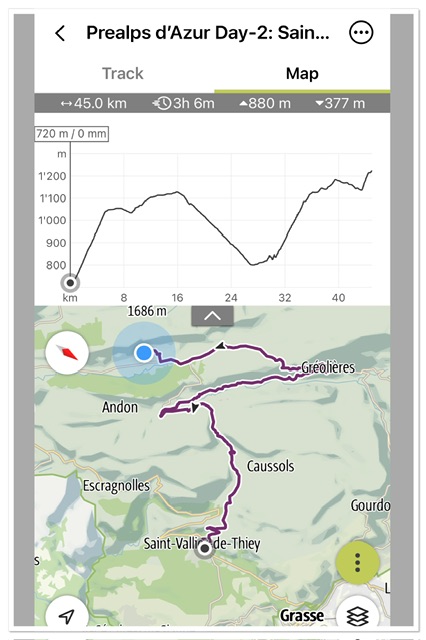
This day was a double-whammy. It started with a 400m uphill with the back-to-back Cols of Ferrier (1041m) and de la Sine (1100m), where we stopped under a tree for a break; always good to take a breather at the end of a climbing stretch. The road is open to beautiful panoramic views, which makes the ascent more bearable.

Then, back on the saddle for the long downhill to Greoliers, a tiny semi-sleepy village with only one open restaurant-cafè, where we stopped for our usual mid-day coffee (coffee and nuts /dry fruits was our standard lunch for the trip).
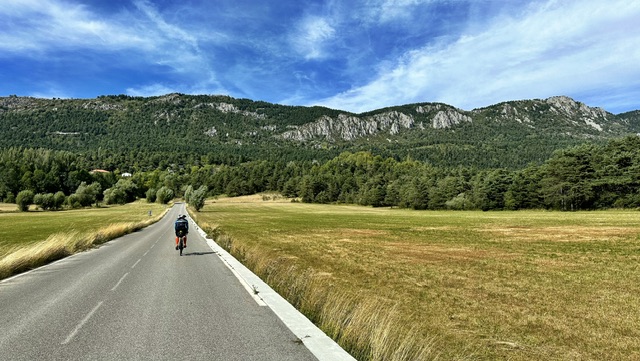
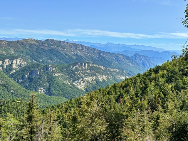
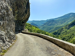
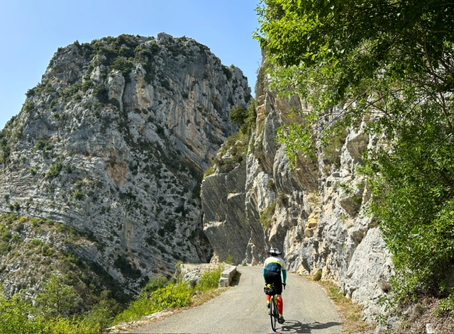
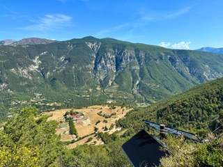
From there, the road starts again a long climb, this time through an incredibly scenic route, with views of distant mountains, and a path cut into grey vertical rocks at vertiginous altitude.


Some castle ruins are also spotted here and there. The landscape is total desolation, plateauing into prairies with natural reserves and animal safaris.
A final push and we arrive at our second lodging in Thorenc. And here, my husband’s bike shoes gave up, the sole completely detached. As luck wanted, the guy at the B&B helped him with a temporary fix of glue and Duck Tape, which saved us until the end of the trip!

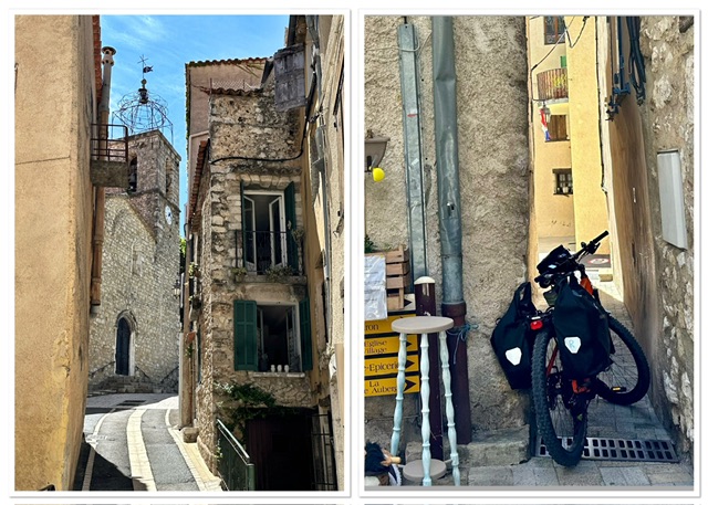
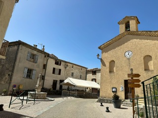
But what about Thorenc? Surrounded by forest, this is a very peculiar village, with a strange architecture and an air of faded glory and times gone by. It feels in total abandonment, with, again, only one tavern to serve us something for dinner (we are not picky at this point!). A bit of history research to discover that Thorenc was indeed a famed holiday resort at the beginning of the 1900s, frequented by White Russians and important Nice families, who built imposing wooden mansions.

All is quiet , no noise pollution here. Perfect relaxing spot for the night.
********************************
DAY-3: Thorenc to Saint-Antonin (47km, +900m)

Breakfast with eggs, cheese, croissant and coffee is enough to keep us going until evening, or almost.
A small stretch of a 200m elevation leads us to the 1,400m altitude of the Col de Bleine.
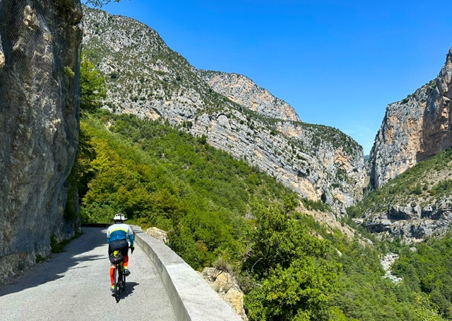
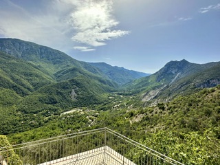
Then we plunge into a fantastic descent of 25km through the forest of Saint Auban, with panoramic views all the way to the Alps.
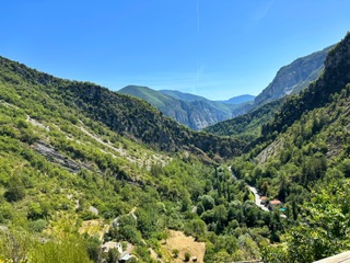
Crossing onto a parallel ridge, we continue with striking views of the valley and of the rocky mountainside, passing the little hamlet of Le Mas (yes, there is a coffee shop if needed).

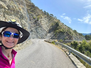
And again, just before Aiglun, another stunning landscape opens before us: vertical rocky walls split by the passing stream (L’Esteron) and its Canyon d’Aiglun; many little stony ponds at the bottom of the Canyon for a refreshing bath; and yet another balcony road cut into the rock for a very scenic ride.


The single restaurant in the hamlet of Aiglun is the perfect stop for our usual coffee-break.

A last uphill stretch for our night destination again through a beautiful scenic road. Thankfully, not many cars cross our path.
And, ooops, our village of Saint-Antonin does not have any restoration points! Only few houses, no bakery, no coffee shop, nothing. Thankfully, I had checked in advance and discovered that our host could make us dinner, for a fee of course.

*******************************
DAY-4: Saint-Antonin to Gorges du Cians to Nice (110km, +1,050m)

I had planned another relatively easy stage for our final day, but our last host convinced us to check out the impressive red rock formations of the Gorges du Cians. And so, in the morning we rerouted northward to this destination.
Too bad that we had to descend first down to the valley for then climbing back up another 700m elevation. But wow, that was worth it! What a stunning geological masterpiece!
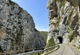
This narrow canyon starts at the bottom with grey mountain walls.

Then at about 1/3 in, a completely new set of mountains appears, all dark red, like if two different continents crashed together.

The road is cut into the red mountains with several small tunnels and overhanging slabs.

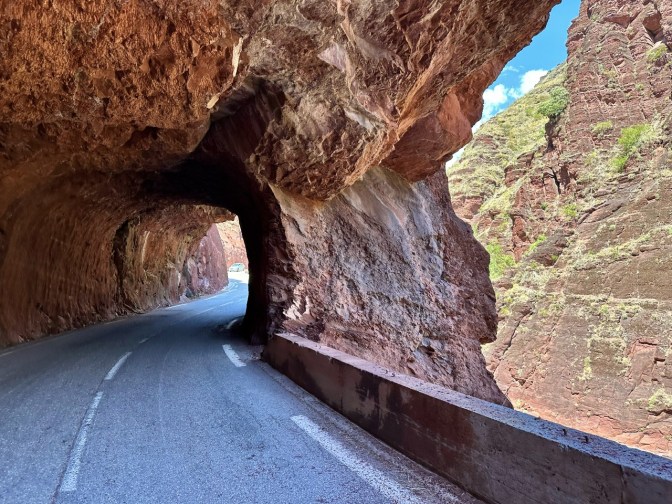
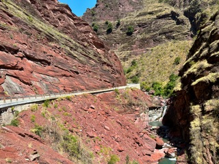
The little canyon stream (Cian) is always visible from the road. The rocks are bare, with minimal vegetation, often sideways showing their geological lines.

The entire length of the Gorges is 22km, descending from the 1,400m of Beuil to the 300m on the river Var, where the Cian empties. Or course we started from bottom to top but we could not make it to Beuil. After 17km of canyon (and a total +1,000m gain for the day), with uphills at times quite steep, our battery and our forces (in temperature >30C) reached a critical point, and we decided to call it quits, turned around and started a 70km-long descent all the way to the sea.

A note of caution at this point. We took the regular road along the Var. This is very busy with car, busses and trucks going often up to 90km/h (and beyond). We chose it because pressed for time and looking for a direct and flat route. But there are better, more secluded bike options . From St-Martin du Var there is also the possibility of taking a dedicated bikeroute all the way to the sea, which we missed.
At the end, after a very long day with 110km and 1,000m gain, we made it to the station in Villeneuve-Loubet at 8pm, right on time for our last train to our destination.
This last day left us with the wish to complete in the future the Gorges du Cians, going all the way up to Valberg or Peone and then redescend via another spectacular red-rock Canyon: the Gorges de Daluis!
A la prochain!
Links to Introduction and other MULTI-DAY Tours:
- BIKING THROUGH SWITZERLAND (with an electric bike)
- NORWAY – Lofoten : Biking above the Arctic Circle
- FRANCE- Perpignan to Avignon, EV8-Mediterranee à Velo (south) in 8 days (510km)
- Cycling the Route des Grandes Alpes , France (southern half)
- FRANCE, Via Rhona (Northern part) , 7-day bike tour
- Cycling the Grande Traversèe du Jura , France
- FRANCE- 9-day Bike Loop in the Landes of Gascony, France: bike routes EV-3 & EV-1

Wow, Alessandra!
–Marilyn
<
div dir=”ltr”>
<
blockquote type=”cite”>
LikeLiked by 1 person
Truly impressive! Congratulations on what appears to be a very challenging tour in high temperatures. Enjoyed following vicariously. The two of you are great role models for what I’d like to do, yet am a long way from actualizing the goal on my own. Thanks for sharing many details and photos. Amazing that France has so much wilderness and undeveloped areas. Best regards, Janice
LikeLiked by 1 person
Thanks for your kind words!
LikeLike